 |
 |


High peaks and deep ravines ...
Wolkberg wilderness area
6-9th August
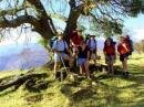
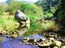
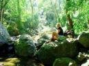
Leader : Robbie Macdonald, who submitted the below photos
Hikers : George Christian, Bev Brockman, Robbie McDonald, Lynette Cooper, Tony Bruisch + Jenny , Jean Smilkstein
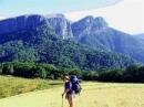
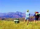
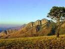
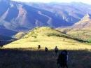
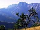
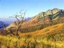
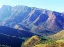
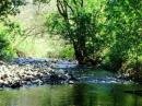
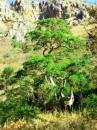
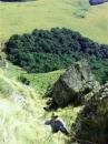
The Wolkberg is a wilderness area situated approximately 80 Km south-west of Tzaneen and is part of the Northern Drakensberg and Strydport ranges. It boasts vertical quartzite krantzes, kloofs and ravines, rivers, indigenous forests and grassland.
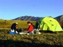
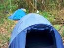
Seven of us set out early one Saturday morning from the Serala Forest Station ?– our mission was to hike the Wolkberg area. Going deep down into the first valley was easy and pleasant walking, if a little steep in parts. At the bottom we walked through forest most of the way, following the course of a stream, with occasional crossings. It was sunny, not too warm, and we meandered along happily until we reached a lunch spot in a leafy glade alongside the river. However, we had been warned that we were in for a steep climb and it was with trepidation that we started out once more. Before long we were walking through the Wonderwoud forest, quite dense in areas, but beautiful, and shady. We filled up with water at approximately three in the afternoon, as this was the last we were to see of the river until lunch time the following day. Water is HEAVY. We trudged up the beautiful forest path, the going was tough, and some form of walking stick is definitely a requirement for this part of the hike. As the shadows grew longer we realized that we should have found the cairn showing the way to the evening campsite, but we had missed it. After clambering around in the bushes for a good 30 minutes we found our overnight stop in a clearing under a canopy of trees, where we were joined by another group of hikers from JHC. We pitched tents, chatted, cooked dinner, chatted some more, and then finally one by one, settled down for the night.
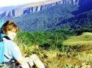
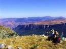
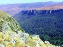
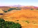
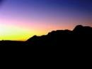
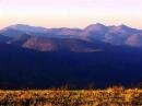
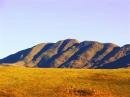
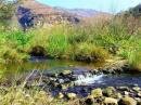
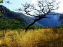
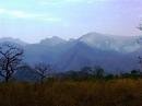
The following morning, with the rising sun streaming through the trees, we packed up and with more trepidation started out to climb the Devil?’s Knuckles, our challenge for day two. Walking out of the edge of the forest we were faced with the formidable Knuckles almost in front of us. To get up to the rock face we had to climb the steep grassy slope almost on all fours, clinging to tufts of grass in order to prevent ourselves from rolling backwards down the mountain. We reached the rock face, and started climbing up through the rocks. At one point there is a length of chain of approximately three metres to cling to, but other than that it was each man for himself. It was well worth the struggle ?– once on top the view of the whole area, and beyond, was breathtaking. We could see forever. But what goes up ?… and soon we were on our way down yet another very steep grassy slope, far down into the valley. This took a good couple of hours to do. We walked through a valley, and down another mountain into an even deeper valley, and finally at lunch time came to rest at another stream. We now had to find our way up to the next campsite, but first, fill up with more HEAVY water to last through the night until lunch the next day. We finally came to rest on top of a grassy hill, where we pitched tents for the night. Behind us we could see the Knuckles in the distance, now in shadow. The view in front was a panorama of mountains, washed by the setting sun in hues of pink and gray, and stretching on forever. We sat in awe and watched the mountains as the sun set, and the stars shone clearly in the night sky.
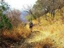
Day three dawned; we struck camp and started our trek down a saddle and into yet another valley. We bushwhacked through a forest of brambles and other clingy, spiky things, until we found a dry river bed which we followed for the rest of the morning. Finally, just as I had begun to despair of ever finding water, we arrived at the river we had set out for in the morning. It was hot, and the cool water and shady trees were most welcome. We lunched by the river and then set out to find the jeep track which was to lead us to our last overnight stop, and finally out of the valley the following day. We walked along the track for the rest of the afternoon, through forest, and along side the river, until we decided that this was far enough. And there we stopped ?– and camped on the jeeptrack, (you sleep in that groove, and I?’ll take this one), much to the consternation of a family of baboons who up until then had thought that actually, they owned this road. We shared their bit of forest for one night, peeping through the canopy at the stars shining brightly above. The baboons squabbled in the surrounding rocks and took a long time to settle.
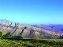
The following morning we set out along the jeep track, and walked, up and up and up. The further up we went the further down into the valley we could see and the further into the distance we could see, and realize how much ground we had covered in four days. The Devil?’s Knuckles were a haze of blue mountains in the distance, and the valley where we had slept the previous night was deep and far, far away.
Wow, what a hike!
Written by : Jean Smilkstein
 |
 |
 |
||
 |
 |
 |
||
 |
 |
 |
||
 |
 |
 |
||
 |
 |
 |
||
 |
 |
 |
||
 |
 |
 |
||
 |
 |
 |
||
 |
 |
 |
||


 |