Route description
The first section of the descent into the canyon is rather steep, but fortunately chains have been provided at the steeper sections. It is advisable to take this section, which takes anything between 45 minutes and one and a half hours, at ease.
The terrain to Palm (Sulphur) Springs consists mainly of large boulders interspersed with stretches of soft, loose sand. The route is mainly on the left bank of the river and about 2km before Palm Springs the descent from the viewpoint of that name is passed. At River Canyon, the weary backpacker can sooth aching muscles in the pools into which the thermal spring flows.
The origin of the palm trees at Palm Springs has given rise to several stories, the most popular being that they grew from date stones discarded by two German prisoners of war who sought refuge in the canyon during World War I. It is believed that one of them was suffering from skin cancer and the other from asthma, but after bathing in the sulphur spring for two months, both were miraculously cured. (This story is often confused with that of the two Germans who fled into the Kuiseb Canyon during World War II to escape internment and whose story has been immortalized in the book, The Sheltering Desert).
The water of the hot spring is forced to the surface from a depth of some 1000m at a flow estimated at about 30litres per second. The temperature of the water which is rich in fluorides, chlorides and sulphates is about 57 degrees Celsius.
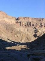
South of Palm Springs the boulders give way to stretches of sand and round river stones and it is advisable to remain on the inside of the river bends. Although this necessitates frequent river crossings, considerable distance is saved in this way. Table Mountain, a familier landmark, is passed about 30km from the starting point. Shortly before the Three Sisters, a short-cut is reached on the right bank of the river. After a short ascent, the impressive Four Finger Rock comes into view. About 30 minutes of the river is crossed once again and the path leads up the slope to the west of the Four Finger Rock. South of this well-known landmark, the Nama sediments give way to deeply dissected mountainous terrain of basement rock.
The canyon now widens considerably and about 2km beyond the Four Finger Rock the grave of Lieutenant Thilo von Trotha, a German officer killed in a skirmish between the Germans and the Nama in 1905 and buried near the site where he fell, is passed. The grave blends in so well with the surroundings that it is easily missed.
It is the mouth of the valley leading from the Four Finger Rock and is situated right up against the western bank.
Ai-Ais is a good day?’s walk further south from here. Although the spring at Ai-Ais is said to have been ?‘discovered?’ in 1850 by a Nama shepherd, searching for stray stock, it is likely that the spring was known to the Stone Age inhabitants of the canyon for thousands of years. The Nama word is said to mean scalding hot ?– a reference to the water temperature which is about 60 degrees Celsius.
Reservations: The Director, Nature Conservation and Recreation Resorts, Private Bag 13267, Windhoek 9000 Namibia Tel: Int. 061 36975

The Fish River Canyon is a deeply dissected landscape fashioned over millions of years by the forces of nature ?– glaciers, water, extremes of temperature and wind. A journey along this magnificent natural wonder does not only present a physical challenge, but also the opportunity to experience unspoilt scenery.
What you need to know:
The route covers approximately 80km if the various shortcuts are followed or about 90km if the course of the river is adhered to and usually takes four to five days to complete.
Backpacking is only permitted from 1 May to 31 August because of extremely high summer temperatures and the danger of flash floods.
Groups must consist of a minimum of three people and are limited to a maximum of 40.
Children must be over the age of 12 and accompanied by at least one adult.
On account of the rugged terrain, it is essential for hikers to be fit. A medical certificate for each member of the group is forwarded with the reservation advice and must be completed by a doctor not earlier than 40 days prior to the trail. It must be handed in at Hobas, the control point near the start of the trail, before setting off.
Hikes are undertaken at ones own risk and the Namibia Government does not accept responsibility for any injuries or accidents. Even during the cooler winter months, temperatures can soar to over 40 degrees Celsius and it is advisable to take a hat and sunscreen lotion along.
During periods of excessive heat, it is recommended that backpacking be restricted to the periods between first light and 11h00 and after 15h00.
Dusk in the canyon is relatively short, making it advisable to set up camp no later than 18h00.
Remember to pack a light raincoat as unexpected thunderstorms are not unheard of during the winter.
It is advisable to descent into the canyon with a full water-bottle.
The first 16km of the trail to Palm Springs is littered with large boulders, which combined with stretches of sand, make the going difficult.
This section is, however, also the most spectacular and it is therefore advisable to hike this stretch at leisure.
Should problems arise, the emergency routes at Palm Springs and at Von Trotha?’s grave can be used to evacuate casualties or terminate the trail prematurely.
No pets allowed.