 |
 |


Enjoy sandstone hills & rugged mountainous terrain ...
Bokpoort hiking trail
Set against a grand amphitheatre of sandstone hills at the foothills of the Maluti mountains, in the Clarens conservancy, is the farm Bokpoort in the eastern Free State.
The beauty of this area lies in the sandstone hills and rugged mountainous terrain. Traces of erstwhile Sesotho huts is testimony of the history of the regions of the ?‘conquered area?’ east of the Caledon River. Bid enthusiasts will enjoy many sightings of the black eagle, jackal buzzard, rock kestrel and black-shouldered kite.
The trail commences through a bluegum plantation to reach and follow a mountain stream all along the ridges of the sandstone cliffs. On the route one will see an interesting eye-tunnel, wind-carved by nature. Tyre ladders facilitate the climbing of the slippery sandstone slopes ascending to the grass areasa above. The trail crosses nine streams and the ideal tea stop is at a well preserved sandstone kraal. From here the route hugs the contours to cross some of the streams past Sesotho ruins. Here hikers can enjoy a ?‘foefie slide?’. The trail reaches the Gwarrie Tree mountain camp at 7km. The 2-5 day hikers will sleep over at this camp. One can hike the extra loop of 4km to the summit of George?’s Pimple at an altitude of 2540m. We recommend this after you have dropped your pack. This climb to the summit with spectacular mountain views of both the Malutis and Lesotho will be worth every step. From the mountain camp, the descent follows an old horse trail, past the swimming hole and back to base camp.
An additional one day hike from the base camp on the adjoining game farm can be done, distance 10km. This trail can be lkinked to the Oumaskraal trail for a 3-5 day hike.
Bokpoort hiking trail: base camp: maximum 24 people.
Mountain camp: 12,
Bokpoort/Oumaskraal 3-5 day trail: 16
Length/duration: Bokpoort hikes A &B; Day 1 - 7km. Day 2 ?– 7km. Oumaskraal link routes: Day 3 ?– Angles Wing ?– 5km. Day 4 ?– 11km. Gamecamp hike ?– 10km.
Degree of difficulty: easy to difficult. Circular routes.
Description: Route A: two days. From base camp up to George?’s Pimple, sleep in mountain shelter and back to base camp.
Route B: 11km, one day. From base camp via Ghwarrie camp back to base campe. Link trails from base via Gwarrie to Oumaskraal for 2-3 days and back or via de Rots.
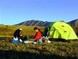
Overnight facilities: Hikers camp: a restored sandstone barn with 3 rooms, 24 beds and mattresses. Electricity. Ablution block. Covered kitchen area with big fireplace open air lapa. Braai facilities provided include ?‘potjies?’ and kettles. Supply own wood. Self-cater or meals from farm kitchen. 2 mountain huts with 3 beds each, equipped kitchen.
Gwarrie mountain camp: can sleep 12 persons ?– 6 per shelter. Supply own ground sheet/mattresses or tents. 2 pit toilets. Water in nearby stream. During dry periods water is provided in drums. Braai grid, collect wood. (Your tents can be taken up by horses at R100 additional.)
Pertinent information: sufficient water points on ascent of trail but no water on descent. Carry own water during dry periods.
Location of trail: 8km from Clarens, 290km from Bloemfontein, 300km from Gauteng, 380km from Pietermaritzburg
Acknowledgement and bookings: Jacana


 |