Home > Trails/venues > Sunday trails > Uitkyk
What a dam view ...
Uitkyk trail
The Uitkyk trail is a well-marked path describing a loop up the northern slopes of the mountains in the vicinity of the Hartbeespoort Dam and within the boundary of the Magaliesberg Protected Natural Environment (MPNE).
There is a fenced car park with toilets and showers at the start/finish point. To begin with, the path follows the contours round a wooded koppie and crosses the main road through a tunnel at an elevation of 1 180 m. From there access is gained to the mountain peak (1517 m). The trail takes between 4,5 to 5,5 hours, depending on the fitness of the hiking group and the length of time spent resting, looking at the fine views or simply stopping for a picnic lunch.
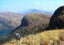
The trail follows a route over varied topography from high grassland, through extensive natural woodland, down rocky kloofs and up the mountain slopes. There is an easy route for the less fit and a scenic route for those seeking a challenge.
The Magaliesberg range is a quartzite escarpment ridge dipping down in a northerly direction to form the southern rim of the Bushveld Igneous Complex. The Crocodile River can bee seen as it follows a geological fault line through the Hartbeespoort Dam northwards to the town of
Brits. The path runs up the main kloof separating the east and west peaks of the Uitkyk property. Rust red walls tower up on each side from dense woodland at the bottom. The path then climbs steeply upwards to the higher ground. This is a wonderful area for bird watching - black eagles and Cape griffin vultures are regularly seen.
 |
|
There are spectacular views from the summit. Immediately to the south is the vast spread of the Dam and on the southern skyline the city of Johannesburg can be seen. To the east one will see the top cable car station from which hang gliders and parasail pilots launch their flimsy craft. To the west the Magaliesberg range comes into view as it stretches away towards Rustenburg. Northwards, vistas of the Brits valley are to be enjoyed with their mix of agricultural and mining activities. On the northern horizon are the granitic outcrops of the Crocodile Mountain and far to the north the Waterberg can be seen on a very clear day.
Uitkyk trail
- Maximum 25 hikers per day.
- Day hikers by permit only.
- Mid-week hikers by special arrangement only.
Length/Duration
- Length 7,5 kilometres; 4,5 to 5,5 hours.
- Degree of difficulty
- Easy to difficult, with optional extreme section.
Facilities
Fenced car park with toilets and showers. Braai stands bring own charcoal/wood.
Pertinent information
- A dry hike, so carry 2 litres of water per hiker.
- Avoid sunburn and be prepared for changes in the weather.
- Do not walk over the R513 use the tunnel.
- Do not walk alone.
Location of trail
30 km west of Pretoria and 50 km from Johannesburg, in the vicinity of the Hartbeespoort Dam
Acknowledgement and bookings: Jacana
Comments made by a JHC hiker.
This trail, which is privately owned, is on 500 hectares steep, craggy, mountainous terrain.
The mixture of indigenous growth is thick, with some 50mm long thorns on branches, stinging nettles and a variety of trees and shrubs.
Almost at the top of the mountain take a well deserved break and witness the magnificent vistas over Hartebeespoort Dam wall and nearby private trout ponds.
The roughly 300m steep climb is demanding but the views of the Hartebeesport Dam and beyond, from horizon to horizon, are worth the effort.
Traverse the mountain on the way back and hike down into a gorge where fading rock wall paintings of indigenous people hunting and spearing wild game can be found in a large cavernous overhang.